
The Hildegard Way
“Hildegardweg” was established with support from the European Union in 2013 and is a 140 km pilgrimage trail through the Nahe river region in Germany. The trail begins in Ida-Oberstein, leading past the monastery ruins of Disibodenburg and Hildegard’s Rupertsburg Abbey, concluding at the Abbey of Saint Hildegard in Einbingen.
The concept of these Hildegardweg tableaux was developed by Dr. Annette Esser and written up by a team of authors facilitated by the Scivias Institute, including sisters of St. Hildegard Abbey: of these, 27 meditation tableaux follow Hildegard’s major mystical work, the Liber Scivias, and 31 information tableaux present Hildegard’s medical, musical and ethical works and on the historical sites where the saint lived. These tableaux are in German and English.
The Hildegard Way pilgrimage trail commemorates one of the most remarkable figures of the Middle Ages — Saint Hildegard von Bingen. The path winds through 135 kilometers (85 miles) of the Rhineland, tracing the key places where she lived, prayed, and created.
Interactive Trail Map
Key Locations on the Trail
The path runs along the historical places where Saint Hildegard lived and worked:
- Niederhosenbach — her probable place of birth and family seat
- Disibodenberg — where she entered the monastery and lived for nearly 40 years (1112–1150)
- Sponheim — where Hildegard was given to her teacher Jutta von Sponheim at the age of eight (1106)
- Bingen am Rhein — where she founded her own convent (c. 1150)
- Pilgrimage Church of St. Hildegard, Rüdesheim-Eibingen — home of the Hildegard shrine
- Benedictine Abbey of St. Hildegard, Rüdesheim-Eibingen — the trail’s final destination
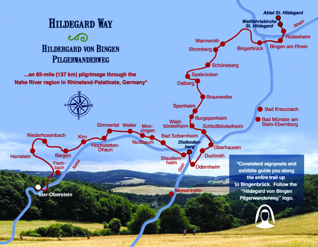
Full Route — West to East
The pilgrimage begins in Idar-Oberstein at the southwestern end and travels northeast through the Nahe River valley before reaching the Rhine:
- Idar-Oberstein
- Herrstein
- Fischbach
- Bergen
- Niederhosenbach
- Kirn
- Hochstetten-Dhaun
- Simmertal
- Weiler
- Monzingen
- Nußbaum
- Staudernheim
- Odernheim
- Meisenheim
- Disibodenberg
- Bad Sobernheim
- Waldbockelheim
- Sponheim
- Dalberg
- Bad Kreuznach
- Bingerbrück
- Bingen am Rhein
- Wallfahrtskirche St. Hildegard, Eibingen
- Abtei St. Hildegard, Rüdesheim
All of creation is a song in praise to God.
Hildegard von Bingen
Geographic Features
The route traverses hilly terrain through the Nahe River region of Rhineland-Palatinate. The Nahe River winds through the western and central portions before flowing into the Rhine at Bingerbrück — the great river that has defined this landscape since Roman times. The trail concludes on the eastern bank of the Rhine at the Abbey of Saint Hildegard, overlooking Bingen from the hill above.